The Ultimate Empire State Trail Active Getaway: Albany to Cohoes
Follow the Hudson River north from New York's capital through historic mill towns, canal districts and waterfront parks on a 12-mile trail that connects two cities shaped by water, industry and revolution.
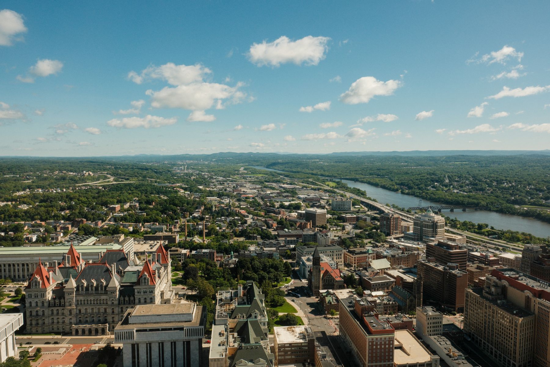
Why the Albany–Cohoes corridor deserves your weekend
The Empire State Trail's Albany-to-Cohoes segment runs twelve miles along the west bank of the Hudson River, threading together Corning Preserve, the Menands riverfront, the Peebles Island State Park causeway, and Cohoes Falls—the second-largest waterfall by volume east of Niagara. You're never more than a few hundred feet from the water, and the flat, paved path makes it accessible whether you're cycling, running, or walking at a sightseer's pace. Spring through October offers the best conditions, with May and September bringing comfortable temperatures in the mid-60s to low-70s and fewer crowds than high summer. The route passes under Interstate 787 twice, crosses historic railroad bridges, and skirts the back fences of old industrial sites that once powered New York's textile and papermaking empire. Locals use this stretch as a commuter corridor, so you'll share the trail with people heading to work in Watervliet and Cohoes, not just weekend warriors.
Albany anchors the southern end with downtown hotels within a ten-minute walk of the Corning Preserve trailhead at Quay Street. You can leave your car parked all day—or all weekend—and cover the entire route on foot or bike without needing to drive again. The northern terminus at Cohoes puts you within sight of the 90-foot Cohoes Falls, which you can view from Overlook Park on North Mohawk Street or from the Series of Locks Park just below the cascade. If you time your trip for late April or early May, the snowmelt pushes the falls to their most dramatic flow, with spray visible from the Peebles Island causeway a quarter-mile downstream. Summer lowers the volume, but the rocks and ledges become more visible, and you can walk closer to the base on the trails that descend from Overlook Park.
Trail logistics: getting there, where to start, and how long it takes
Most visitors start at the Corning Preserve riverfront park in Albany, accessed from Interstate 787 via the Colonie Street exit. Free parking fills the lots along Corning Place on weekends by mid-morning in summer, so aim for an 8 a.m. arrival if you want a guaranteed spot. The preserve's northern lot, near the Jennings Landing amphitheater, puts you directly on the trail with public restrooms and water fountains open April through October. From there, the trail runs north under the Dunn Memorial Bridge, past the Albany Yacht Club, and into a wooded corridor that buffers the path from Route 32. Cyclists cover the twelve miles to Cohoes in about an hour; walkers take three to three-and-a-half hours at a sightseer's pace with photo stops. The trail is fully paved and flat—you gain only 60 feet of elevation over the entire route—so road bikes, hybrid bikes, and strollers handle it without trouble.
If you'd rather start in Cohoes and ride south, park at the Peebles Island State Park visitor lot off Delaware Avenue in Cohoes. The island sits at the confluence of the Hudson and Mohawk rivers, and the trail crosses onto the island via a narrow causeway with water on both sides—one of the most photogenic stretches of the entire 750-mile Empire State Trail. From Peebles Island, you can make a short detour west to the Cohoes Falls overlook before heading south toward Albany. The round-trip ride from Albany to Cohoes and back covers 24 miles, which most recreational cyclists complete in two-and-a-half to three hours with a lunch break. If you're walking one-way, arrange a pickup in Cohoes or use a rideshare to return to your hotel in Albany—the trip takes about fifteen minutes by car via Route 32.
What you'll see: mills, bridges, islands and the canal that changed New York
The first three miles out of Albany hug the riverbank through Corning Preserve's landscaped paths, then pass behind the Albany Medical Center campus and under the Twin Bridges carrying Interstate 787. Just north of the bridges, you'll cross the boundary into the Town of Colonie, and the trail enters a wooded buffer zone that screens the highway noise. Around mile four, you'll see the back of the Menands municipal complex and the old railyard that once served the New York Central line. The trail here runs on the former railbed, and you can still spot remnants of ties and ballast in the gravel shoulders. At mile six, you cross into Watervliet, passing the back fence of the Watervliet Arsenal—the oldest continuously operating arsenal in the United States, manufacturing artillery since 1813. You won't see much of the facility from the trail, but informational plaques at the Arsenal Street crossing explain its role in every American conflict from the War of 1812 onward.
North of Watervliet, the trail enters the Green Island Bridge corridor and crosses onto Peebles Island via a causeway built on the old Delaware and Hudson Railway bridge abutments. The island itself is undeveloped parkland crisscrossed by gravel trails that loop through second-growth forest and along the riverbank. Bald eagles nest here in winter, and great blue herons fish the shallows in summer. The main Empire State Trail cuts across the island's southern tip, but it's worth detouring onto the perimeter trail to see the stone ruins of the Cluett, Peabody & Company bleachery, which operated from the 1850s until 1972. The bleachery processed cotton fabric for the collar and shirt industry that once dominated Troy and Cohoes, and the ruins—brick foundation walls, iron window frames, and a partially collapsed smokestack—sit quietly in the woods above the Mohawk River. From Peebles Island, the trail crosses back to the mainland at Cohoes, emerging at Ontario Street a few blocks west of Cohoes Falls.
Cohoes Falls and the Harmony Mills: the reward at the end of the ride
Cohoes Falls drops 90 feet over a horseshoe-shaped ledge of Lockport dolomite, a rock formation that also underlies Niagara Falls. The Mohawk River funnels through a narrow gorge just upstream, concentrating the flow into a thundering curtain of white water visible and audible from blocks away. The best overlook sits in Overlook Park at the corner of North Mohawk Street and School Street—a small municipal green with a railed viewing platform cantilevered over the gorge. Spring runoff in April and May can push the flow past 20,000 cubic feet per second, enough to rattle windows in the nearby rowhouses and throw mist halfway up the gorge walls. By August, the flow drops to 2,000 cubic feet per second, and the underlying rock ledges become visible, forming stepped terraces that you can see from the platform. If you walk down School Street to the Series of Locks Park, you can descend a staircase to river level and stand at the base of the falls, though high water in spring makes the lower trail impassable.
Two blocks south of the falls, the Harmony Mills complex sprawls along the north bank of the Mohawk—a sprawling assemblage of red-brick textile mills, clock towers, and warehouses that once employed 4,000 workers and produced more cotton fabric than any other site in the United States. The mills operated from 1837 until 1930, and the buildings now house apartments, though the exteriors remain largely unchanged. The Empire State Trail doesn't pass directly through the complex, but it's a five-minute walk east from the Ontario Street trailhead. Mill No. 3, the massive five-story building with the mansard roof and central clock tower, is the most photographed, especially in late afternoon when the sun lights up the brick facades. If you're visiting on a weekday, the Cohoes Public Library on Remsen Street keeps a small exhibit of Harmony Mills artifacts and historic photos in its local-history room, open noon to 6 p.m. Tuesday through Saturday.
Where to stay and how to structure a two-day itinerary
Downtown Albany hotels put you within walking distance of the Corning Preserve trailhead and the city's restaurant and brewery district along Broadway and North Pearl Street. Mid-range properties along State Street and Lodge Street offer parking and breakfast, with rates typically lowest Sunday through Thursday. You'll want a ground-floor room or elevator access if you're bringing bikes, and some properties offer secure bike storage in a garage or utility room—ask when you book. The Hampton Inn on Lodge Street and the Hilton Albany on State Street both sit about a ten-minute walk from the Quay Street trailhead, and both put you within two blocks of the Capitol building and Washington Park if you want to add urban sightseeing before or after your ride. Budget an extra thirty minutes if you're planning to walk from your hotel to the trailhead with bikes in tow.
A sensible two-day itinerary starts with an afternoon arrival in Albany on Friday, a Saturday morning ride to Cohoes and back, and a Sunday morning walk through Washington Park or the New York State Museum before checking out. If you ride round-trip from Albany, you'll cover 24 miles and spend three to four hours on the trail, leaving the afternoon for brewery visits or a walk through the historic Pastures neighborhood south of downtown. Alternatively, drive to Cohoes on Saturday morning, park at Peebles Island, ride south to Albany, and arrange a pickup at Corning Preserve—this lets you ride with the prevailing south wind at your back and finish in the city where you'll find more lunch and coffee options. The Corning Preserve Cafe, a seasonal kiosk near Jennings Landing, serves sandwiches and cold drinks May through September, but it closes by 4 p.m., so plan your timing accordingly. If you're visiting in winter, the trail remains open and plowed, but services and restrooms shut down, and you'll need to dress for wind off the river.
What to skip and what to add if you have an extra day
The stretch through Watervliet and Menands is the least scenic section of the route, squeezed between Route 32 and the back fences of industrial properties, and it offers no services or notable landmarks beyond the Arsenal Street historical marker. You can't realistically skip it if you're riding the full trail, but don't expect postcard views between miles four and seven. The Peebles Island causeway, the Cohoes Falls overlook, and the southern Albany riverfront are the highlights; if you have limited time or energy, drive to Peebles Island and ride the three-mile loop around the island itself, then walk to the falls. You'll see the best scenery in an hour and avoid the monotonous middle miles. Similarly, the Harmony Mills are impressive from the outside, but they're private residential property now, and there's nothing to do there beyond taking photos and reading the historical marker on Mohawk Street.
If you have an extra day, extend your ride north from Cohoes to Waterford and the Champlain Canal locks. The Empire State Trail continues another four miles through Waterford to Lock 2, where you can watch boats transit the canal and cross the Hudson on the Waterford Flight pedestrian bridge—a cantilevered walkway attached to the old railbridge piers. Waterford sits at the confluence of the Hudson and Mohawk and marks the southern terminus of the Champlain Canal, so the waterfront here is a tangle of locks, dams, islands, and bridge crossings that makes for fascinating industrial sightseeing. The round-trip from Albany to Waterford covers 32 miles, which is a full day for most recreational cyclists. Alternatively, drive east to Troy and spend a morning walking through the downtown historic district along River Street and Fifth Avenue, then visit the Troy Waterfront Farmers Market on Saturday mornings. Troy offers more dining options than Cohoes and a more walkable downtown, and it's only a ten-minute drive from most Albany hotels.
Questions, answered
Can I rent bikes in Albany for the Empire State Trail?
Steiner's Sports rents hybrid and mountain bikes from their store on Central Avenue in Albany, about three miles west of downtown. You'll need to pick up and drop off during business hours, and they require a credit card hold. Some hotels partner with local shops for guest rentals, so ask when you book. There are no bike-share stations along the trail itself, and no rental kiosks at the Corning Preserve trailhead, so arrange your bike before you arrive at the trail.
Is the Albany–Cohoes trail safe for solo travelers or families with kids?
The trail is fully paved, well-marked, and heavily used by local commuters and recreational riders, so you're rarely alone on the route during daylight hours. The sections through Corning Preserve and Peebles Island are the busiest and feel most secure. The Watervliet stretch between miles four and seven passes through industrial areas and can feel isolated midweek, but it's open and visible from Route 32, and you'll see regular foot and bike traffic on weekends. Families with younger kids should start at Peebles Island and ride the three-mile island loop, which is shorter, more scenic, and free of road crossings.
When is the best time to see Cohoes Falls at peak flow?
Late April and early May bring the highest water volume, fed by snowmelt from the Adirondacks and the Mohawk River watershed. The falls can exceed 20,000 cubic feet per second during peak runoff, creating dramatic spray and noise. By midsummer, the flow drops to 2,000 cubic feet per second or less, exposing the underlying rock ledges. Visit after heavy rain in autumn for a middle-ground flow with fall foliage in the gorge. The overlook in Overlook Park is open year-round, but the lower trails at Series of Locks Park close during high water and ice season.
Are there restrooms and water along the trail between Albany and Cohoes?
Public restrooms and water fountains are available at the Corning Preserve Jennings Landing area in Albany and at the Peebles Island State Park visitor center near Cohoes, both open April through October. There are no facilities on the trail itself between these two points, a distance of about nine miles. The Watervliet stretch has no services, and the wooded sections north of Menands offer no commercial stops. Plan your hydration and restroom breaks accordingly, and carry water if you're riding in summer when the seasonal kiosks may be closed.
Can I connect the Albany–Cohoes trail to other Empire State Trail routes?
Yes. From Cohoes, the trail continues north through Waterford to the Champlain Canal corridor, eventually reaching Saratoga Springs 35 miles north. From Albany, the trail runs south along the Hudson to Rensselaer and beyond, connecting to the Hudson Valley Greenway that reaches New York City. The Mohawk Hudson Bike Trail branches west from Albany, following the Mohawk River to Schenectady and eventually to Buffalo. The Albany–Cohoes segment is a short, manageable piece of the 750-mile statewide network, making it ideal for a weekend sampler before committing to longer multi-day routes.
Doing good is the business: every booking through Albany Eco funds one verified tonne of carbon removal — same room, same price, no markup.
Start Your Search